ROADS, URBAN SPRAWL, AND WATER
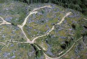
I cannot end the discussion of streams and ditches (Part 2) without accounting for roads and urban sprawl because they also have a dramatic effect on the quality of watery commons. Roads affect the quality, quantity, and distribution of water in the soil of a catchment, regardless of whether they are graveled and constructed to extract timber or paved and constructed as access to homes in a housing development. The construction and use of a road severely compacts and otherwise disturbs the soil that, in turn, increases the rate of runoff, may reduce the flow of subsurface water, and alters the equilibrium of shallow groundwater. Unfortunately, the information needed to understand the effects of a road on the regime of surface and subsurface water is still limited.
Unless water infiltrates deep into the soil of a water catchment, it runs downhill and reaches the cut bank of a logging road or even a major highway, which brings it to the surface, collects it into a ditch, and puts it through a culvert to begin infiltrating again. The water then meets another road cut, and so on. Water is sometimes brought to the surface three, four, or more times before reaching a stream. Water is purified by its journey through the deeper soil, but not by flowing over the surface of the ground. Roads bleed water from the soil the same way cuts in the bark bleed latex from a rubber tree or sap from a sugar maple.
Roads bleed water from the soil the same way cuts in the bark bleed latex from a rubber tree or sap from a sugar maple.
In fact, ditches and gullies, such as those that formed on the downhill side of culverts passing under roads, function effectively as pathways down which water flows. The denser the network of roads, the greater the drainage of water over the soil's surface, and the less time it takes for peak flows to occur and dissipate.
This poses a question: How deep into the soil is deep enough for water to avoid the ditches at the bases of banks alongside roads? I have seen roadbeds blasted out of solid rock to depths of fifty or sixty feet (15.5 to 18 meters), and I have seen water seeping out the "bottom" of this same rock into the roadside ditches in July and August, a predicament symptomatic of the disruption in the flow of water. This means precious water is brought to the surface of the ground, where it not only evaporates but also becomes polluted by sediment, oil, and chemicals from the road's surface and human garbage in the ditch. Consequently, roads have a negative, cumulative effect on the hydrological cycle of a water catchment and on the purity of the water that ultimately reaches human communities.
by
Chris Maser


For example, a logger drains waste oil from a loader onto a landing. Where does the oil go? It soaks into the soil and is carried downhill by water and gravity. True, the oil will be diluted by the time it reaches the ditch of the road twenty feet (6 meters) below the landing, but it is still polluting the soil as it goes. With the winter rains of the fifth year, the oil collects in the ditch, is mixed with other oil that leaked from passing vehicles, is flushed through the culvert under the road, and continues its journey. Given enough time, it will reach the stream 100 feet (31 meters) below the road and pollute the stream that flows into the small reservoir that supplies the local community with drinking water.1
Disrupting the flow of water through the soil on steep slopes, even forested slopes, can cause instability and increase erosion during a severe rainstorm or as snow melts. Such conditions in the vicinity of the seeping water can cause soils to become saturated with little or no infiltration, which that in turn weakens them and leads to greater local runoff of water over the surface of the soil and hence greater erosion.2

Rubber tree plantation in Malaysia.
On the other hand, roads and streets are paved in housing developments within water catchments surrounding a community, thereby creating an impervious coating over the surface of the land. This impervious layer prevents water, both rain and melting snow, from infiltrating into the soil, where it can be stored, purified, and can recharge existing aquifers and wells. Instead, the water remains on the surface of the roads and streets, where it mixes with pollutants that collect on the pavement.
Because paved roads and streets are lined with curbs and gutters, the now-polluted water is channeled from the paved surface into a storm drain. In addition, each house has an impervious roof that collects water and channels it into gutters along the edge of the roof. Upon collecting water, the gutters channel it, more often than not, out to the street, where it joins water from the street going down the storm drain. It is then conducted either directly into a sewage treatment plant or directly into a ditch, stream, or river.
In any event, the water is not usable by the local people. Beyond that, the storm water either adds to the cost of running the treatment plant, where it must be detoxified, or it pollutes all the waterways through which it flows, from its point of origin into the ocean.
The effect of roads, streets, parking lots, and the area covered by houses, all of which eliminate the infiltration of water, is cumulative. Enough roads, streets, parking lots, and roofs over time can alter the soil-water cycle as it affects a given community. Remember, the quality and quantity of water is an ecological variable, irrespective the fact that many linear-thinking economists and "land developers" consider it an economic constant.
Even if water was a constant, a variable is introduced with construction of a single road. Constructing and maintaining multiple roads only compounds the variable. In addition, intensive forestry, such as clear-cutting, alters the water regime that affects how the forest grows. In this way, a self-reinforcing feedback loop of ecological degradation in a water catchment is created, altering the soil-water regime that, in turn, alters the sustainability of the forest that, in turn, affects the soil-water regime in a never-ending cascade of cause and effect. Eventually, the negative effects are felt in those communities that are dependent on a given water catchment or drainage basin for their supplies of potable water.
We humans can continue to degrade the forested water catchments and impoverish our supply of water, or we can risk abandoning our conventional thought pattern and, with a strong, concerted commitment, reverse the trend—one of the main purposes of treating forests as biological living trusts. In the final analysis, we must remember that only so much water is available, and with a change in the global climate, that amount may become even more variable and unpredictable than it already is. That notwithstanding, more water cannot be found in a courtroom, no matter how hard we try or who holds the priority rights to the water already available. And so it behooves us all as national/global citizens to consider how we care for the sustainability of the stream-order continuum that constitutes the water catchments—lest the reservoirs and wells go dry.3
HOW WE THINK ABOUT WATER CATCHMENTS
Although most people talk about "watersheds," where "shed" means to get rid of water, I think of the same areas as "water catchments." A "water catchment" is an area that captures precipitation, be it rain or snow, stores it, purifies it, and releases it slowly over time, thus helping to ensure a sustainable supply of quality water for human use—provided the biophysical health of the water catchment is protected and the water it produces is prudently used.
As with any problem, there are solutions, but we tend to think about and look for solutions only where the symptoms are obvious, a situation seldom apparent with water catchments. The problem with water catchments normally begins with the headwaters, the first-order stream and its catchment basin, usually a trickle far removed from human habitation. A first-order water catchment is always a special case; in fact, it is probably the only part of the land in which the hydrology has any semblance of ecological integrity since it is the headwaters and so controls the initial water quality for the whole catchment basin.4


A farmer is clearing the riverside forest—the dark area with piles of debris—because it is viewed as "non-productive" unless it is farmed, despite its intrinsic value to the health of the stream (left). Farming right up to the edge of a stream or river guarantees that much of the non-point-source pollution from agriculture will go directly into the nation's waterways (right).
Our thinking, and so our view of the world, is generally limited to a kaleidoscope of special cases because we choose to focus on "discrete" parcels of land as "real estate." If, for example, we deal only with a reach of stream (the visible portion of a stream between two bends in the channel), we perpetuate our inability to understand that particular reach of stream because we view it as an independent variable in an interdependent world, a relationships that cannot physically exist. We must, instead, view the reach of stream in relation to its entire catchment—and ultimately to the entire catchment basin—as an interdependent whole. If we view a reach of stream in this way, we enhance our ability to understand both the reach of stream and the water catchment because each is defined by its relation to the other. Understanding how a reach of stream relates to the whole of its catchment is like understanding how a single chair relates to a room.
For example, mines in the Huancavelica region of present-day Peru have long yielded cinnabar ore, which is composed of mercury sulphide. Based on lake sediment cores, the earliest evidence for mining and metallurgy in the Andes begins about 1400 BCE at Huancavelica, which predates the emergence of complex Andean societies.
Huancavelica, which is located at roughly 11,800 feet (3,600 meters) has the largest mercury deposit in the New World and, as such, was a locus of early mining to extract cinnabar for the production of vermillion, which is a vivid red pigment that was obtained by grinding pure cinnabar. However, mercury-laced dust was released during the process of grind the cinnabar. In fact, prior to the Spanish invasion of South America, the production of mercury-laden dust peaked about 500 BCE and about 1450 AD, which corresponds to the heights of the Chavín and Inca States, respectively. (The Chavín people developed a civilization in the northern Andean highlands of Peru from 900 BCE to 200 BCE, with a peak around 600 BCE.)
Initially, mercury pollution caused by the Chavín people seems to have been limited to cinnabar dust in the extration of virmillion. But once the Incas moved into the region around 1400 AD, smelting was adopted and the level of mercury pollution increased almost tenfold and traveled 140 miles (225 kilometres) to a lake, which suggests that as least some of the Inca's intense mining must have been for the mercury itself, thereby generating as least gaseous mercury.
When the invading Spanish discovered the mine, which they dubbed the "Santa Barbara mine," they increased the removal of cinnabar, which was used to extract silver form its ore during the smelting process, but so many people died of mercury poisoning the operation became known as the "mina de la muerte" ("the mine of death"). Moreover, the mining of mercury at Huancavelica has spanned the past 3,500 years.5 During that time, the streams and rivers would have been polluted by mercury-laden dust and gaseous mercury, which would have found its way downstream as a generalize water pollutant, beginning in the headwater streams draining the high Andean lakes. Whereas the preceding discussion concerned what is called hard-rock mining in a given location, small-scale gold mining is still causing widespread siltation from eroding goldfields, as well as the concentration of potassium, aluminum, iron, and mercury in South American streams—all of which has only one way to go, downstream.6
Yet, because we choose to focus only on discrete parcels of land as real estate, our worldview and so our thinking, is generally limited to a kaleidoscope of special cases. If we deal only with special cases, such as a mile of stream, we perpetuate our inability to understand that particular mile of stream, the entire stream, and the water catchment as an interdependent whole. If, on the other hand, we deal with a particular mile of stream (a special case) in relation to the whole catchment (the common denominator), we enhance our ability to understand both the mile of stream and the catchment because the mutual relationship defines each. As I said before, understanding how a reach of stream relates to the catchment as a whole is like understanding how a single chair relates to a room.
If you were to stand in the doorway and survey a room, you would see the chair both in the room and in relation to the room, but when you focus only on the chair you can no longer see the room or the chair's relationship to it. Unfortunately, most people do not see that the first-order water catchments (head waters) are the initial controllers of water quality for supplies of domestic water. For this reason, exploitive forestry allows logging to occur down to the edges of both first- and second-order streams, even in municipal water catchments, because the timber is thought to have greater immediate economic value than the water—and this says nothing of the destructive aspects of mining. Moreover, since politically important fish, such as salmon and steelhead, do not live at the high elevations in which most of these small streams occur, the water is deemed to be of no visible, economic importance.7 The invisible importance of the water in a catchment, far from the tap that dispenses it, becomes visible only when the water reaches the habitat of politically important fish and human communities, where its is deemed valuable because it supports a commodity (fish) and becomes usable in the domestic sense.
ENDNOTES


©Chris Maser 2009. All rights reserved.
![]()